Decision-Support Tools
OK NSF EPSCoR Research Product Clearinghouse
The Research Product Clearinghouse portion of the EPSCoR website provides access to a diverse body of resources from the OK NSF EPSCoR Research Infrastructure Improvement Award No. OIA-1301789 (2013-2018), “Adapting Socio-Ecological Systems to Increased Climate Variability.” Resources derived from this project include decision-support tools and systems that will prove beneficial for researchers, decision-makers, and individuals. The Decision Support page provides a link to all the decision-support products developed as a result of this project. The tools outlined below are an important part of the OK NSF EPSCoR research team's work, which was produced in collaboration with contributing programs and agencies. [Click titles to access material.]
Geospatial Modeling
Desalination in the United States: A Movie and Multidimensional Map in KMZ Format
This research material is an interactive multidimensional geospatial model representing U.S. desalination plants in the United States for a 63-year period (1950 to 2013).
Instructional Video, Movie (mp4), Cesium, KMZ Temporal Desalination Plants
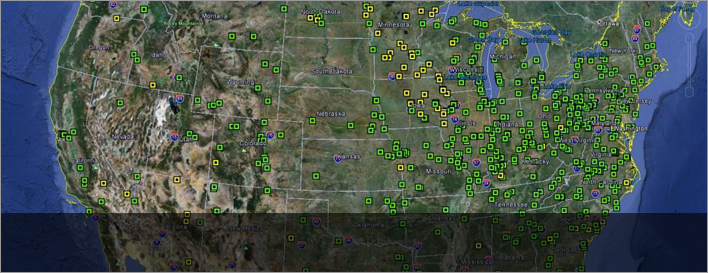
Groundwater Level Changes in Oklahoma and Texas: KMZ Format
This research material provides geospatial groundwater visualization models to assess availability of groundwater resources for agricultural, industrial, and municipal uses both in Oklahoma and Texas in the time frame of 2003–2014.
Water: Data & Tools
Oklahoma Soil Moisture Mapping System
This new web-accessible soil moisture mapping system is designed to create and deliver high-resolution soil moisture maps for the entire state of Oklahoma on a daily basis. Soil moisture is an essential climate variable, and this first-of-its-kind mapping system will provide Oklahomans with detailed soil moisture information that is relevant to decisions in diverse fields including agriculture, fire danger management, and hydrologic forecasting.
Oklahoma Water Use Calculator
The Oklahoma Water Use Calculator compiles water usage amounts for different household activities based on self-reported use and calculates the cost of that consumption at local rates. The calculator also determines the money saved based on a 10 percent reduction in home water usage.
Weather: Data & Tools
County-Level Social Vulnerability Fact Sheets
Fact sheets detailing Oklahoma counties' social vulnerabilities to weather events have been developed and are accessible via download. The sheets, which have been developed for all 77 Oklahoma counties, are based on 2010-2014 social and ecological data gathered through the Mesonet, MSIS-Net, NOAA, and the U.S. Census Bureau. Methodology and data source information may be accessed here.
Social Vulnerability Validation Story Map
This ArcGIS story map was developed to communicate the series of research studies and procedures used to generate and validate the social vulnerability indices for Oklahoma.
Questions? Contact Honey Bryan, Outreach Coordinator, at 405-744-7645 or [email protected].