Ethnographic Story Maps
The Social & Environmental Histories of Oklahoma Watersheds
The Research Product Clearinghouse portion of the EPSCoR website provides access to a diverse body of resources from the OK NSF EPSCoR Research Infrastructure Improvement Award No. OIA-1301789 (2013-2018), “Adapting Socio-Ecological Systems to Increased Climate Variability.” Resources derived from this project include decision-support tools and systems that will prove beneficial for researchers, decision-makers, and individuals.
The Ethnographic Story Map page provides access to a unique set of informative digital ArcGIS Story Maps, which highlight the multi-faceted ethnographic research conducted by members of the EPSCoR project, including Dr. Jack R. Friedman, Team Leader and Co-PI, Center for Applied Social Research, University of Oklahoma (OU); Dr. Michael Stanton, OU; and Dr. Tony VanWinkle, OU. The material includes narrative text, images, and multimedia content that bring the team's research into focus via a user-friendly format. The material described below is an important part of the OK NSF EPSCoR RII award and was produced in collaboration with contributing programs and agencies. [Click titles to access material.]
An Ethnographic Study of the Kiamichi Watershed of Southeastern Oklahoma
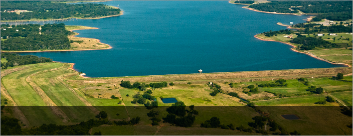
The Kiamichi Watershed, located in southeastern Oklahoma, is a unique geographical and cultural landscape. This story map brings together many different aspects of the region including its local culture, history, economics, politics, hydrology, and ecology within the broader climate conditions that affect these individual features. The Kiamichi Watershed lies within the Choctaw Nation of southeastern Oklahoma, with a rich and often controversial history of land and resource use. Economic diversification through multiple income sources is and has been the key to long-term economic survival in a region where timber and agriculture are the primary means of subsistence. The southeast region of Oklahoma is mountainous, with a higher average rainfall than western areas of the state. But, as is the case statewide, water is an important and controversial topic. A key issue in the Kiamichi region is water use and allocation. Specifically, controversy exists over Lake Sardis and concerns regarding having enough water in the lakes and streams to support flora, fauna, and humans' continued personal and business pursuits in the region. Learn how these factors come together to shape some of the current conflicts in and around the watershed, how they will shape future challenges in the area, and how people are working together to find solutions to some of the region’s dominant issues.
An Ethnographic Study of Oklahoma's Lower Cimarron River Watershed
The Lower Cimarron River Watershed spans a range of classic Oklahoma landscapes, linking west-central and north-central Oklahoma. The watershed contains a complex mosaic of rural, semi-rural, suburban, agricultural, and industrial landscapes that extend from just north of Oklahoma City through the Stillwater micro-politan area, to the east-central part of state, northwest of Tulsa. This story map explores the relationships between these landscapes, along with local cultural and industrial history, politics, ecology, and economics, in order to understand the distinct resource concerns in the watershed and how they may influence, or be influenced by, broader climatic conditions and future climate scenarios.
Ethnography in the Upper Washita Watershed & Caddo County, Oklahoma
The Upper Washita Watershed embodies a distinct sub-region in the state of Oklahoma. Occupying the northeastern edge of southwestern Oklahoma, Caddo County is not only one of the most agriculturally productive regions of the state, it also displays a remarkable array of natural resources and boasts a colorful and complicated cultural history as home to substantial living populations of seven of the state’s thirty-eight federally recognized tribes. This story map brings these unique threads together, along with local economics, politics, hydrology, and ecology, in order to understand the area's significance in relation to broader climatic conditions. Learn how these elements shed light on major resource concerns in and around the watershed, and how they will shape future challenges.
Ethnographic Research in the North Canadian Watershed
The North Canadian Watershed feeds the primary water supply reservoirs for Oklahoma City and spans a rural region that is projected to experience increasing water shortages in the coming decades. This story map, which focuses on a number of counties surrounding the city of Woodward, Oklahoma, describes the complex relationship between changing human land-use and the natural resources of the region, all within the context of the harsh and unforgiving environment of the most arid region of the four watersheds in Dr. Friedman’s study. The project captures centuries of unprecedented change: The shift from the prehistoric Native American presence in the region to the population growth associated with the railroad’s expansion into the West, and the critical role the region played in the movement of cattle along the Great Western Trail. Farmers struggled to eke out a living in a land plagued by drought, tornadoes, and severe ice storms. Beginning in the 1950s, there was a transition toward an increasing reliance on the energy industry, including, most recently, a growing commitment to wind power.
----------
Questions regarding the content of the Story Maps and/or the related ethnographic research should be directed to Dr. Jack Friedman at [email protected].
Photo credit: NRCS USDA