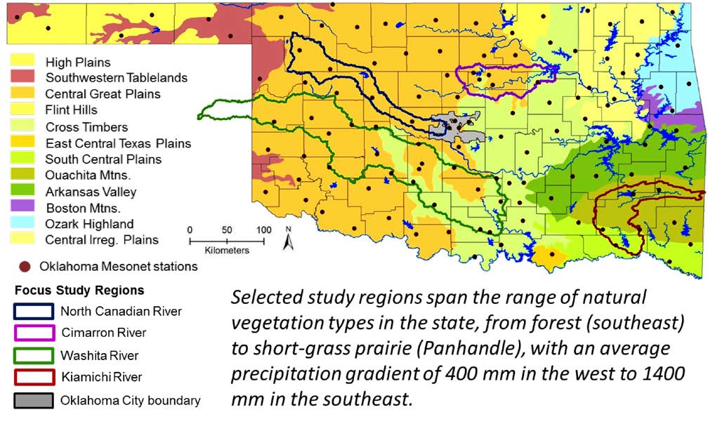
Washita River Watershed Study Area
The Oklahoma NSF EPSCoR team’s socio-ecological research efforts in the Washita River Watershed study area are diverse and address the special needs and concerns of the region. The following are among the projects that have been completed or are ongoing:
- Long-term, in situ ethnographic research examining how different perceptions and practices related to water availability, sustainability and conservation have been shaped by tribal identity, personal/family/regional experiences of the Dust Bowl and past droughts, politics, geography (esp. access to groundwater), and how people use the land (agriculture, ranching, etc.).
- Economic research into the value of recreational resources in the region with a special focus on Ft. Cobb Reservoir, a substantial recreational destination in the region.
- Research into how farmers do or do not use and/or value various conservation programs and the implications of this for a broader understanding of stewardship in the region.
- Hydrological research on the impact of stream bank erosion in the Ft. Cobb watershed, which feeds into Ft. Cobb Reservoir. This research examines not only the broad hydrology of stream bank erosion, but also involves local farmers and land-owners in the discussion by seeking to understand how they perceive stream bank erosion risks and the value of riparian forest planting as a means of mediating stream bank erosion.
- Sociological and anthropological research into how Native American tribes perceive the risks of climate change. This research includes seeking to understand the on-going planning that tribes are making to increase resilience and to prepare for predicted consequences of climate change.
- Substantial landscape-level analysis of important questions, drawing on remotely-sensed data. Research includes: algal blooms in Ft. Cobb Reservoir, crop-composition and productivity, and a cataloging effort to account for all of the service water in the region (as part of a statewide effort).
- Research into the role that shelter belts – lines of trees first planted in the Washita-Caddo region in the 1930s and 1940s to help combat soil erosion that occurred during the Dust Bowl – continue to play in the region. Specifically, we are examining how these shelter belts have become part of the human perception/understanding of the landscape, how they provide ecosystems for birds and mammals, and how they do or do not inform our understanding of woody encroachment into the Plains.
ABOUT THE WATERSHED
Location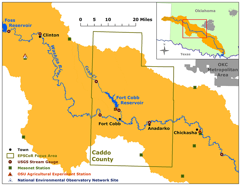 Originating in the Texas panhandle, the Washita River enters west-central Oklahoma in Roger Mills County. From there it flows 575 miles in an east-southeasterly direction to its confluence with the Red River at Lake Texoma, in the south-central part of Oklahoma. Situated mostly within Oklahoma’s Cross Timbers Transition ecoregion, Caddo County’s landscape encompasses a mosaic of rolling-to-level cropland, native prairie, and “improved” rangelands in its north, northwest, west-central and southern sections.
Climatology
Using Oklahoma Mesonet data we calculated the range of average monthly temperatures and precipitation totals, and an overall monthly average for each of those variables.
Average monthly summer temperatures in Caddo County range from the upper 70s to lower 90s, with an overall monthly average temperature hovering right around 80ºF for both July and August. Winter temperatures range from near freezing (32ºF) to the lower 40s, with an overall monthly average temperature lingering near 40ºF.
Two precipitation maximums occur during the year for this area. The primary maximum often comes during May and June, where precipitation averages roughly 5 inches each month. A secondary maximum occurs during October, where as much as an additional 10 inches of precipitation can fall.
Unique Qualities
Site selection for the present study is limited more specifically to the Upper Washita River watershed, centered around the town of Fort Cobb in Caddo County, Oklahoma. Chosen not only for its location on the north bank of the Washita River, the town of Fort Cobb lies at the river’s intersection with two additional major hydraulic resources that have heavily shaped the area’s development since the middle of the twentieth century. These are Fort Cobb Lake reservoir, built on a tributary of the Washita River four miles north of its namesake town, and the Rush Springs aquifer, one of Oklahoma’s major bedrock aquifers. The development of the latter has been a largely private affair focused overwhelmingly on crop irrigation (though the county contains a substantial portion of non-irrigated cropland as well), while the former serves as both a recreational resource (as the principal draw of Fort Cobb Lake State Park) and the source for municipal drinking water supplies. The Washita River also serves to delineate historic and contemporary tribal boundaries, with the Wichita, Caddo, Delaware tribal jurisdiction (and former reservation) lying north of the river, and the Kiowa, Comanche, Apache jurisdiction (and former reservation) to the south. The land tenure relations that are the legacy of tribal allotment continue to shape contemporary land-use patterns in the greater area.
Landscape and Natural History
Situated mostly within the state’s Cross Timbers Transition ecoregion, Caddo County’s landscape encompasses a mosaic of rolling-to-level cropland (39% of the land base as of the 2012 agricultural census) and native prairie and “improved” rangelands (52.1% of the land base) in its north, northwest, west-central and southern sections. The county’s tremendous geological diversity ranges from red rock sandstone formations in the north to the limestone rangeland of the Slick Hills in the southwestern corner. The easternmost section of the county, lying in the Northwestern Cross Timbers ecoregion, contains the bottomlands of the Sugar Creek watershed (a major local tributary of the Washita) interspersed with wooded sandstone canyonlands. The county’s rivers and streams are characterized by sandy, unstable streambeds and deeply incised banks of highly erodible red prairie soils. In this transitional rainfall region, typified by periods of extended drought interrupted by severe flood events, the combined effects of water-induced soil erosion and wind-induced soil blowing has been the twin impetus for concerted conservation efforts, especially since the Dust Bowl era. More recently, with the development of both modified dry-land tillage practices (low and no-till) and irrigation infrastructure drawing from the Rush Springs Aquifer, water conservation has become a new focal point for area farmers and resource managers.
Resources for Researchers: Models Developed & Calibrated for Use in the Washita Watershed
- Cybercommons Data Repository – EPSCoR Datasets
- Becker, M. F. 1998. Steady-state simulation of ground-water flow in the Rush Springs Aquifer, western Oklahoma. USGS, Water-Resources Investigations Report 98-4082
- Becker, C.J., D.L. Runkle, and Alan Rea. 1996. Digital data sets that describe aquifer characteristics of the Elk City Aquifer in western Oklahoma. USGS, Open-File Report 96-449
- Runkle, D.L., M.F. Becker, and Alan Rea. 1996. Digital data sets that describe aquifer characteristics of the Rush Springs Aquifer in western Oklahoma. USGS, Open-File Report 96-443