
EPSCoR Researchers: Measuring and Predicting Drought in Oklahoma
For decades, Oklahoma has experienced major droughts significantly impacting both surface water and groundwater resources. Extreme droughts can lead to economic losses especially in the agricultural sector. Groundwater is one of the most important natural resources for agricultural production and can also be used as a supplemental water source for public use. Overuse of groundwater resources has become a serious problem in the state, especially in the Oklahoma Panhandle, which heavily relies on the Ogallala Aquifer. Since natural replenishment of groundwater through precipitation may take many years, the challenge remains as to how the water demand can be sustainably managed in order to mitigate the excessive use of groundwater resources and its repercussions.
To address those issues, Dr. Jadwiga “Jad” Ziolkowska from the University of Oklahoma (OU) together with Reuben Reyes (OU) developed a decision-support tool that will monitor and help predict groundwater levels in Oklahoma over time. “We use groundwater levels as indicators and predictors of drought in Oklahoma,” Ziolkowska said. “Our evaluation tool will be an important resource since consistent monitoring of groundwater availability in the state is limited,” Ziolkowska added. Dr. Ziolkowska’s research team developed a geospatial and temporal visualization model to evaluate changes in the groundwater levels over time from 390 groundwater wells across Oklahoma. These wells were selected using the U.S. Geological Survey water database. "We used a combination of normalized in-situ averages of groundwater levels and the Palmer Drought Severity Index (PDSI) values in assessing and validating changes of groundwater levels,” Ziolkowska said.
“Through the years of our analysis since 2003, water levels in most wells have been declining, which indicates impacts of recent droughts. We also verified that groundwater well levels and soil moisture levels strongly correlated with PDSI measured at the state level and separately for all nine climate regions in Oklahoma,” Ziolkowska said.
“Our results and model can help decision-makers, water managers, and scientists identify and predict geospatial and temporal patterns in changes of groundwater levels, and help predict potential impacts as well as potential locations of concerns for decision makers in their efforts to design sustainable water management programs,” Ziolkowska said.
“Our ongoing collaborative research between the Department of Geography and Environmental Sustainability and Oklahoma Climatological Survey (Oklahoma Mesonet) aims at correlating impacts of precipitation, soil moisture and groundwater resources both statistically and geospatially. Those results will help better understand temporal changes in groundwater levels subjected to weather variability. Moreover, in collaboration with the State of Oklahoma Climatologist, Dr. Gary McManus, we work on developing a novel water scarcity index for Oklahoma that can be further transferred and applied to measure and help predict drought in other regions and states in the US as well as other countries around the world. Finally, we plan on expanding this research to consider socio-economic and environmental implications of drought in different economic sectors and regions in Oklahoma,” Ziolkowska said.
Users are able to visualize changes in groundwater levels in Oklahoma through the interactive geospatial visual tool via http://www.hitechmex.org/OK_TX/index.html.
Funding for this project was provided by the National Science Foundation under Grant No. OIA-1301789 through OK NSF EPSCoR.
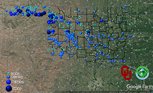
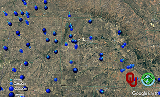
Top image: Screenshot of groundwater wells in Oklahoma, 2011-2014. Bottom image: Screenshot of groundwater well levels in a region of Oklahoma, 2003-2014.
-----------------
Story written by Pamela Abit, EPSCoR program coordinator. For more information about this research project, contact Dr. Jadwiga Ziolkowska at [email protected].