Kiamichi River Watershed Study Area
The Oklahoma NSF EPSCoR team’s over-arching research goal in the Lower Cimmaron River Watershed is to assess the study area’s vulnerability and resiliency under the influence of drivers of change (climate, human behavior, public policy, land use and woodland encroachment) using an integrated coupled human-natural systems approach.
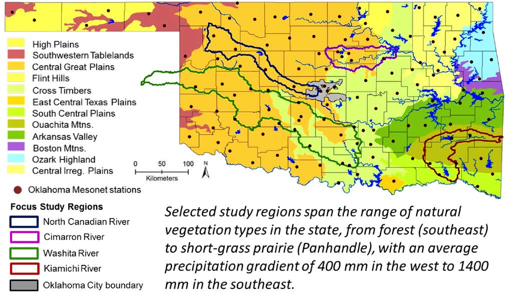
ABOUT THE WATERSHED
Location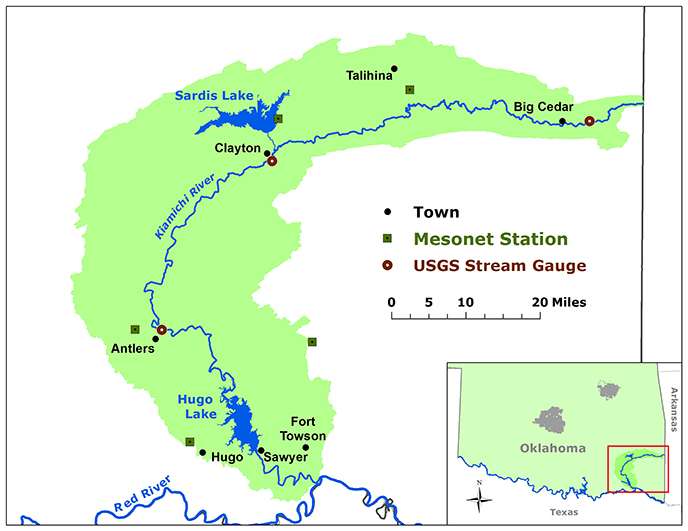 The Kiamichi River Watershed is located in southeastern Oklahoma. The headwaters originate near the Arkansas border in the upper Ouachita Mountains, and flow west, then south from its source in LeFlore County, Oklahoma down to the Red River, just south of Hugo, Oklahoma. The entire basin area is located within Oklahoma and covers roughly 1,821 sq. miles (3010 sq. km) and encompasses two major lakes: Sardis Lake and Hugo Lake.
Climatology
Using Oklahoma Mesonet data from three stations in the Kiamichi Watershed, we calculated the range of average monthly temperatures and precipitation totals, and an overall monthly average for each of those variables.
Average monthly summer temperatures in the watershed range from the mid 70s to lower 90s, with an overall monthly average temperature hovering right around 80ºF for both July and August. Winter temperatures range from upper 30s to the lower 50s, with an overall monthly average temperature lingering near 40ºF.
The month of May has the most variable precipitation range, with as little as a few inches in some years to over 20 inches of rainfall in others.
Unique Qualities
The Kiamichi River is home to a variety of mussels and a wide diversity of fish species. In addition, the watershed itself is home to three federally designated endangered species: the Indiana bat, the red-cockaded woodpecker, and the leopard darter.
During various interviews for this project, many participants discussed changing land-use patterns, moving from subsistence based agriculture in the past, to a developing tourism-centered economy today. Water was a focal point during this discussion and is a recurring theme in most of these interviews. Individuals emphasized that the notion of surplus water in the southeastern part of the state was incorrect and pointed out that, even in a year of well above-average rainfall, the area still suffered moderate drought during the summer months because of the soils and geographic landscape of the region. Another ecologically focused perception discussed was the impacts of red cedar on the water supplies, particularly springs in the area. Beliefs echoed by several interviewees, was that long-term fire suppression in the region had caused the rampant spread of red cedars which had, in turn, caused many of the springs in the area to stop flowing. One individual based this belief on the experience of a controlled burn in the area, after which several of the springs that had been dry for years began once again to produce water. This interview and the ongoing participation of other individuals in communities throughout the Kiamichi Region continues to provide valuable experiential local knowledge of ecosystems within the region. The data produced by these interviews provides a more in-depth understanding of regional vulnerabilities and socio-ecological resilience that will supplement the bio-physical sciences and so enhance the resolution of the larger study.
Landscape and Natural History
The Kiamichi basin is covered by 65.5% forested lands while 25% is pastureland. Although annual precipitation ranges between 48 and 56 inches annually, the steep topography and thin soils of the Ouachita and Kiamichi mountains results in the Kiamichi Watershed having very high runoff per square mile. Therefore, the uplands are highly susceptible to drought conditions. The Kiamichi Basin, much like most of the Ouachita Mountains region in Oklahoma, is extremely rural, with a natural resource- and tourism-driven economy. Cattle and forestry, along with tourism, anchor the economy. The EPSCoR-focused research looks at the socio-ecological impacts of changing land and resource use patterns over time and how those changes have shaped perceptions of risk and subsistence strategies within the watershed.
There is a significant amount of forest area utilized for pine plantation, but most forest within the watershed is privately held. Private management forest ranges from plantation to periodic timber harvest to no tree cutting at all. The water resources of the Kiamichi watershed are an economic and environmental concern. The Kiamichi River has a number of endemic aquatic species including fish and mussels, which have been shown to be vulnerable to low flows and high stream temperatures, either or both of which could be affected by either human water management or climate change. Additionally Sardis Lake, formed by the impoundment of Jacks Fork Creek, has been targeted as a potential water source for Oklahoma City, which would involve substantial water exports from the watershed.
Resources for Researchers: Models Developed & Calibrated for Use in the Kiamichi Watershed
- Cybercommons Data Repository – EPSCoR Datasets
Vaughn, C.C., and J.P. Julian. 2011. Incorporating ecological costs and benefits into environmental flow recommendations for Oklahoma rivers: Phase 1, southeastern Oklahoma (interim). OWRRI Report
Morton, R.B. 1988. Simulation of ground-water flow in the Antlers aquifer in southeastern Oklahoma and northeastern Texas. USGS, Water-Resources Investigations Report 88-4208
_____________
More about EPSCoR’s Kiamichi Study Area research: Among the many models that have been developed to create the Kiamichi Watershed Integrated Model, researchers have developed a process-based Stream Temperature Model. The model uses measured instream water temperature and streamflow as the upstream boundary condition, and then ambient climate conditions (hourly solar radiation, air temperature and wind speed) with assumptions about cloud cover, stream shading, and bottom energy absorption to model stream temperature at downstream points at distances up to 80 km. The model is focused on the months of July, August and September (typically the hottest and lowest flow months), and is capable of modeling the moderating effects of releases from Sardis Reservoir in southeastern Oklahoma. The model results were presented in terms of cumulative time above thermal maximum (CTMax) for general fish guilds present in the Kiamichi River. The CTMax values were determined through experimental treatments. Stakeholders are currently being engaged to develop scenarios for the model, including critical temperature, streamflow, and dam releases. The downstream distance of ameliorating temperature effects is being considered for known locations of sessile organisms.